
For the approximately 120,000 people who walk, bike, or motor up and down it every day, San Pablo Avenue is a vital East Bay transit corridor. The street runs through seven cities, including Oakland and Berkeley, and its proximity to Interstate 880, I-580 and I-80 make it a common alternative traffic route. From its well-known bars to its popular veggie eateries, busy shopping centers, and community movie theaters, the roadway is an eclectic cultural hub that people love and rely on.
Its heavy use, though, comes with a price.
More people get into accidents on San Pablo than on almost any other major traffic corridor in Alameda County. It’s especially dangerous for pedestrians and bicyclists, who account for 64% of the serious injuries and deaths caused by collisions on the roadway, even though they make up less than 10% of the people who use it every day, according to the Alameda County Transportation Commission.
Oakland’s dangerous roadways
This article is part of our special series looking into traffic and pedestrian safety in the city. Read more.
Between 2008 and 2013, the most recent period that transportation injury data for San Pablo Avenue was available at the time of the ACTC studies, close to 150 bike collisions occurred on the street, dozens of pedestrians and cyclists were injured, and four pedestrians and one bicyclist were killed. Cars were most often at fault due to improper turning, driving on the wrong side of the road, or speeding, but pedestrians also made unsafe crossings.
San Pablo Avenue also has one of Alameda County’s largest bus riderships, but the bus lines are often seriously delayed or slowed due to heavy traffic congestion.
With massive population and job growth expected to take place along the corridor over the next 20 years—an estimated 75,000 new households and 150,000 new jobs within half a mile of the avenue—local organizers and elected officials want to make San Pablo safer and more efficient before it gets even more dangerous.
But in recent years, the idea of a complete San Pablo redesign—one that would prioritize public transportation, walkers, and bikers over cars—became a real possibility with institutional backing.
In fact, the desire to change the roadway’s design to improve conditions has been in the works for years. In the mid-2000s, Caltrans repaved most of San Pablo Avenue’s 13 miles and modernized some intersections. Unfortunately, as we’ve seen with other local corridors struggling with antiquated, car-centric designs, these quick fixes did not lead to long-term safety improvements or less congested traffic.
The San Pablo Avenue Corridor Project, a joint effort between seven cities, two counties (Alameda and Contra Costa), and the state of California, has been quietly and steadily moving forward since 2016. It is a part of Plan Bay Area 2040, a massive state-mandated transit and land-use project that will invest approximately $300 billion in the region over 24 years.
“The project is a huge opportunity to rethink and redo San Pablo Avenue for the 21st century.”
Oakland Councilmember Dan Kalb
Phase one of the San Pablo project, which wrapped up this winter, created a long-term vision for the corridor, drawing on years of studies by the Alameda County Transportation Commission, AC Transit, and others. That vision—a vibrant transit hub with dedicated lanes for faster, likely electric buses, wide bike lanes, and improved walking infrastructure—is expected to be realized by 2040.
Currently underway, phase two will involve the finalizing of plans, additional fundraising, and initial design changes in the four participating Alameda County cities: Oakland, Berkeley, Emeryville, and Albany.
By the end of this year, final street safety designs should be approved by the county transportation commission and city councils in the four cities. Funding will be solicited from state agencies, and grants could also be awarded by year’s end. And city transportation agencies will hold public meetings and conduct community outreach to residents and businesses to solicit feedback and address any design or equity concerns.
“The project is a huge opportunity to rethink and redo San Pablo Avenue for the 21st century,” said Oakland Councilmember Dan Kalb, who has been the city’s point person on the project for years and has a role on the county transportation commission’s board.
Whether by redesigning street signals, redrawing bike lanes, or making buses run more efficiently, Kalb said government agencies should be doing everything they can to get travelers on San Pablo Avenue out of their vehicles. “Some people are going to drive cars no matter what, but reducing the number of people taking single car trips reduces traffic ingestion, greenhouse gas emissions, and the risk of people getting hit.”
With the project now entering this important new phase, we set out to explain some of the project’s early findings, look at how cities within its scope area are approaching design differently, and preview what’s to come in 2022, including opportunities for public input.
A street in need of better design

Since the cities that San Pablo Avenue runs through are all quite different, Alameda County Transportation Commission members expected it would take years to break ground on a plan that would fit their needs.
The commission got the ball rolling in 2017 by funding a $1.75 million study of the existing conditions along San Pablo Avenue. The goal was easy to explain but difficult to execute: Find out what’s working about San Pablo, and what’s not, across multiple cities. The report would also include a survey of community members in each city that sought to find how they used the corridor and what the biggest transit challenges were, including the lack of signage, congestion spots, and broken facilities.
The study looked at the entirety of San Pablo Avenue, from Oakland in the south to Richmond in the north. Tess Lengyel, executive director of ACTC, said it was critical to include the parts of San Pablo Avenue that are in Contra Costa County. “Travelers don’t have the same boundaries as government agencies,” she noted. “They need to safely and reliably get to their destination.”
The transportation commission published its report in 2018. It found that most collisions on San Pablo Avenue happened within 100 feet of intersections, mostly affecting bikers and walkers. Crossing the street was also difficult because it lacked medians, adequate crossing signals, and stop infrastructure.
The study also revealed that the southern portion of San Pablo Avenue, particularly between 40th Street and Broadway in Oakland, is one of the most dangerous sections to walk or bike. The central portion, comprising Berkeley, Albany, and El Cerrito, has the most car collisions. One intersection on Solano Avenue in Albany was found to be the most dangerous spot for bicyclists.
This last fact surprised some who’d believed that the parallel Ohlone greenway, a bike and pedestrian pathway connecting Berkeley and Richmond, would reduce bike collisions. But bike advocates like Robert Prinz, a former board member of Oakland’s Bicyclist and Pedestrian Advisory Commission, noted that bicyclists often end up on roads with heavy car traffic, even when they have dedicated parallel routes. Why? Because they need to go to retail and cultural hubs like everyone else.

With speeding being a major cause of collisions, the transportation commission also sought to measure the average speed of buses and cars on the corridor’s bus lines, in part to determine whether a dedicated bus lane could make the transit system more efficient without increasing pedestrian danger.
AC Transit’s local service lines were found to be slower than its rapid transit buses, which started running in 2003. The study also found that both bus options are slower than cars during on and off-peak transit hours—not ideal if the goal is to persuade more drivers to use the bus. Local service buses drove between 9 and 12 mph on average, while rapid transit bus speeds were measured at 10 to 15 mph, and personal vehicles were between 14 and 19 mph.
The study also looked at the number of trips people took on or near San Pablo Avenue to work, shop, and otherwise live their lives.
It found fewer people use San Pablo as a “pass-through” area than as a corridor to reach a specific destination. Better transit options, it followed, might incentivize people to give up their cars and take public transit, ride a bike, or simply walk more if they felt safer doing so. Indeed, the report suggested that over 10,000 of the 135,000 peak-period car trips taken each day along the avenue could be eliminated in the future by giving people improved pedestrian and bike infrastructure, and public transit options.
Business owners and shoppers surveyed by the commission said they wanted to know how dedicated bike and bus lanes might affect parking. Not surprisingly, according to the ACTC report, the most-used parking spaces on San Pablo are the ones near heavy retail and business districts, such as downtown Oakland. But parking spots in non-commercial areas of San Pablo, and in most loading zones, are often vacant. It’s still unclear how this will impact design decisions around any future bus or bike lanes.
“What we heard was, ‘We’ve gotta do something now.'”
Tess Lengyel, ACTC executive director
The commission also studied the demographics of communities living adjacent to the corridor and found that 56%, or roughly 42,000 households, fall into “equity priority” groups. These include lower-income households, minorities, and people over 75 years old. The average household incomes in Oakland and Berkeley among the population studied were $23,862 and $35,710, respectively.
Emeryville Mayor John Bauters, who recently became the chairman of the commission, said he was not surprised with most of the findings from the project studies. As a bike and bus rider on San Pablo Avenue, he said he understands the need for infrastructure improvements. “There are few linear options to move around here and people want reliable and safe transit,” said Bauters.
Addressing business owners’ concerns about how parking and loading will be impacted by the new designs, he added, will also be important.
Dave Campbell, the advocacy director of Bike East Bay, told The Oaklandside that parking should be examined in the context of the pandemic, which he believes has changed people’s shopping (and by extension, driving) habits.
“I’m hearing more businesses are reliant on dropoff and pickup activities than in-person client and customer visits,” he said. “So where are these cars going to wait while they are picking up and dropping off? As a bike advocate, that’s a significant change since even two years ago.”
Cities disagreed over design concepts
By late 2018 and into 2019, after months of community focus groups and business outreach, the county commission engaged with city transportation departments to develop new road designs. Together, they came up with four options.
Concept A was the most pedestrian- and bike-friendly. It removed a lane on each side of the road to make room for a dedicated bus lane in the middle of the street, much like the rapid bus lane recently installed on International Avenue in Oakland. It also placed protected bike lanes curbside, all but eliminating most parking spots.
Concept B also had a center bus lane and removed curbside parking, but added a northbound lane for extra car traffic during busy commutes, while Concept C kept the curbside parking and the two-lane road design, leaving the bus lane next to the sidewalk while adding a protected bike lane.
Concept D featured dedicated bike- and pedestrian-friendly paths similar to the Ohlone Greenway that runs parallel to San Pablo Avenue in Berkeley and Albany, on other streets. Lengyel said this last concept would be difficult to execute in Oakland and Emeryville because of the orientation of the street grid. “In the southern part of San Pablo, you don’t have parallel routes that are as close to it and as convenient [as you do in Berkeley and Albany],” she said.
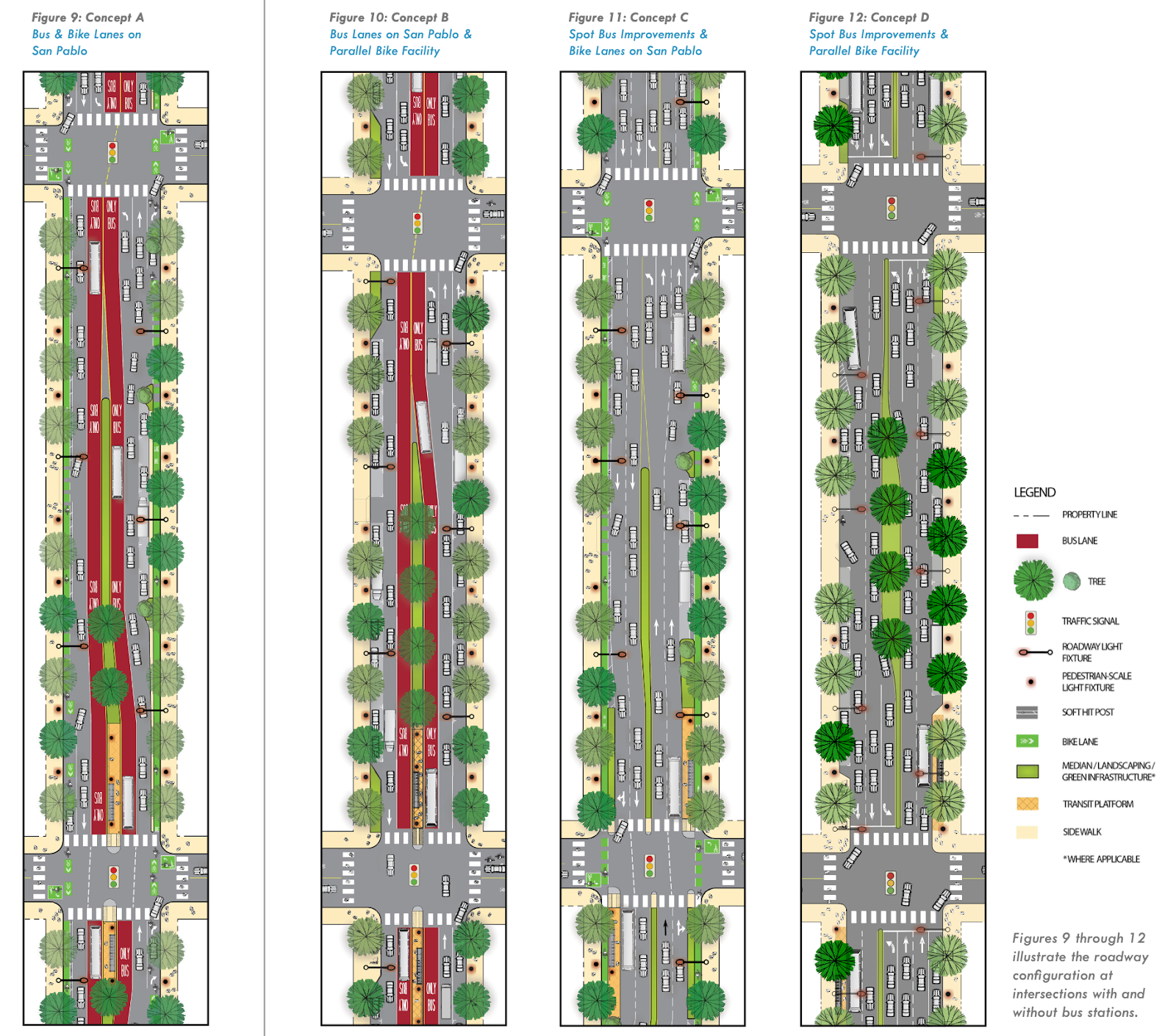
When presented with the options, the cities disagreed about which design elements were best.
Oakland’s Department of Transportation lobbied for a protected bike lane similar to the one now on Telegraph Avenue, which is separated from the main roadway by either parked cars, cement barriers, or planters. Berkeley and Albany officials also preferred a cycle lane separate from the roadway, but wanted one similar to the shoreline track in Alameda and the roughly quarter-mile strip next to Albany’s police headquarters.
Berkeley and Albany did not want a center lane for a bus, while Oakland and Emeryville were open to it. None of the cities expressed an appetite for a rapid bus line running the length of the avenue, although ACTC officials told The Oaklandside this may still be an option they could pursue in the coming years.
With fewer resources and smaller transportation departments, San Pablo, El Cerrito, and Richmond decided they needed more time to study their parts of the roadway and opted out of a full-scale redesign in the short term.
But the four cities in Alameda County were able to narrow down the possible options. Oakland and Emeryville would use parts of concepts A and B, while Berkeley and Albany would mix in concepts A, B, and D.
“The goal is not making San Pablo exactly the same,” Kalb told The Oaklandside. “The goal is to make it a lot better than it is today in a way that makes sense for the people who are traveling the corridor and who live there.”
Oakland and Emeryville will get bike and bus lanes
Throughout the community outreach process, commissioners heard from residents, especially in the four Alameda County cities, who expected near-term fixes to improve safety.
“What we heard was, ‘We gotta do something now,’” Lengyel told us. “2040 is the big horizon. So let’s do incremental steps now and not take 20 years to develop the project.”
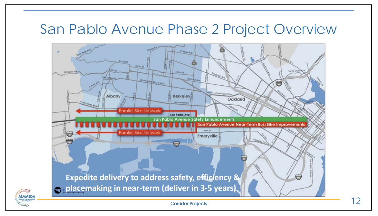
By the end of 2021, all four of the participating cities in Alameda County—Oakland, Emeryville, Berkeley, and Albany—decided that it was in the public interest to pilot a program to increase safety on San Pablo Avenue within 3-5 years. County officials say this timeline will allow for the approval of final designs and funding.
“This is a rapid schedule for a major infrastructure project for environmental, design and construction in a complex environment,” a spokesperson for ACTC told The Oaklandside.
Initial improvements in all four cities will include pedestrian crossings with loud, audible signals, easy-to-see crosswalks with diagonal striping, and rapid flashing beacons controlled by pedestrians that alert cars to slow down. Bus stops will also get a refresh, with new curb ramps to help disabled people better access public transportation, while some will get improved lighting and hardware fixes, including new seats.
Dedicated bus and bike lanes will be added in Oakland and Emeryville, work that should begin within the next several years. Where the new bus lanes will be placed—in the middle of the street or next to the sidewalk—has not been decided. OakDOT officials, however, are leaning toward the latter.
Oakland District 1 Councilmember Dan Kalb has been part of the project as an ACTC board commission member (he is currently an alternate). He expects further discussion in 2022 around the tradeoffs between bike and bus lane benefits for pedestrians, and parking needs for curbside loading and unloading at businesses on the avenue.
While Kalb is supportive of the bike and pedestrian lanes, he also thinks the current street median on the Oakland section of the road should be removed to give trucks greater loading zones, while smaller islands at intersections for pedestrians and bicyclists could remain.
“That would allow flexibility [on the road] alongside the new bike and traffic lanes. I want to make sure that our retail businesses can operate their business or at least have access to alternatives that meet their needs,” Kalb said on a call.
Kalb acknowledges that the median removal may not happen with tight budgeting and residents opposing delays. It would take “tens of millions” to remove the median, he estimates, and incorporating middle-lane loading zones might slow down planning.
The pilot will also add better crossing tech at road intersections (a big win for bicyclists), including on transit hubs like Grand Avenue in West Oakland. County transportation director Lengyel told The Oaklandside that in 2022, these plans will be “refined” and that people should reach out to their transit departments and the commission itself to participate in virtual meetings and be heard.
The transportation commission’s next meeting will be held on Feb. 24 and the public can participate on Zoom. People can also see previous videos of the commission on Vimeo.
Bus lanes won’t run through Berkeley

The new bus and bike lanes proposed for Oakland and Emeryville will only extend a few blocks into Berkeley.
That’s because the Alameda County Transportation Commission decided against building transit lanes through Berkeley and Albany, citing “significant concerns” heard during the project’s public outreach about taking a lane away from cars and reducing parking along the avenue.
Transit advocates view the decision as a missed opportunity. Many regard the Berkeley stretch of San Pablo as an ideal place for dedicated lanes that could improve public transit for residents—many of whom live far from the nearest BART station—by freeing buses from traffic.
Research from commission staff found stretches of San Pablo in Berkeley and Albany carry more bus riders than any other part of the corridor in Alameda County. And a survey conducted as part of the commission’s outreach found 55% of Berkeley respondents supported plans that included bus lanes.
“It’s very disappointing,” Darrell Owens, a housing and transit advocate with East Bay Transit Riders Union, said of the commission’s decision. “The longer they wait, the higher the costs are, (and) the political calculus doesn’t change when you stretch it out for five years.”
“We don’t think that any of these improvements we’re making in Berkeley and Albany are throw-away. They’re all things that can be built on.”
Cathleen Sullivan, ACTC planning director
The decision has echoes of Berkeley’s move more than a decade ago to reject a plan for bus lanes along Telegraph Avenue. This time around, though, Berkeley officials supported the plan for transit lanes. Mayor Jesse Arreguín and councilmembers Terry Taplin and Rashi Kesarwani, who represent the corridor, joined Owens’ group and other advocates last year in encouraging the commission to reconsider.
Their effort came up short, with commission officials warning in November that adding several miles of new transit lanes at this point could delay the project as a whole. In a small concession, the commission approved a plan to extend the bus and bike lanes about a third of a mile into Berkeley—to San Pablo’s intersections with Russell Street and Heinz Avenue—so they connect with the city’s Bicycle Boulevard network.
Instead of dedicated lanes, plans call for building upgraded “in-lane” bus stops through the rest of Berkeley and Albany that will let drivers pick up and drop off riders without having to pull over or merge back into traffic, which should make boarding faster. The project would also fund traffic-calming measures to encourage bicyclists to use Ninth Street as a parallel route to San Pablo, as well as improved intersections to make crossing the avenue safer for pedestrians.
Taplin and Kesarwani both said they hope to use the coming years to build more support for transit and bike lanes on San Pablo among residents and businesses. The extension into South Berkeley, Kesarwani said, will also give residents a sense of what could be possible along the entire San Pablo corridor.
“Our community will have an opportunity to experience that transit improvement, and hopefully, that can lay the groundwork for additional improvements,” she said.
Similarly, commission officials emphasized the project would not be the end of efforts to speed up buses on San Pablo.
“We don’t think that any of these improvements we’re making in Berkeley and Albany are throw-away,” Cathleen Sullivan, the commission’s planning director, said at a November meeting of its Planning, Policy and Legislation Committee. “They’re all things that can be built on.”
What’s next

Last week, the commission approved the allocation of more than $3.5 million in funding through Measure BB—a countywide sales tax to support transportation improvements—for planning, design, and engineering work on the corridor project.
But conversations with residents along the corridor will continue over the next several months, according to Lengyel. She said the commission currently has plans to reach out to about 150 businesses along San Pablo Avenue in Oakland and Emeryville.
“Right now, we’re in the throes of doing very specific door-to-door business outreach in Emeryville and Oakland to address implications of adding a bus and bike-only lanes through those areas,” Lengyel said.
The Alameda County Transportation Commission typically holds monthly meetings that the public can attend virtually. Oakland residents interested in the project can also check the weekly or monthly public meeting agendas of Oakland Public Works, OakDOT, the Oakland City Council, and AC Transit, all of which will continue to be involved. But the best way for residents to stay in the loop will be to join the county’s email list for project updates, by sending a request to sanpabloave@alamedactc.org.
An environmental review of the project will also likely be published in the next few months.
Since the southern part of San Pablo Avenue, which includes Oakland and Berkeley, is a state highway (State Route 123), ACTC needs approval from the California Department of Transportation for any design or structural additions. According to the ACTC, its officials are in weekly discussions with Caltrans about the project’s scope. Still, there is no deadline for the state to approve changes.
“Businesses, institutions, schools—how will these changes help them?”
Dave Campbell, Bike East Bay
Most of the design decisions will be made by spring 2022, according to Lengyel, although small adjustments are likely to take place over the next year.
The county expects to finish an interim project report by the end of March, which it will use to apply for state and federal grants. Lengyel said the commission is planning to apply for millions being made available for Bay Area projects through the Municipal Transportation Commission. The county also hopes the project can benefit from the $30 billion California state surplus, Gov. Gavin Newsom’s proposed $22 billion transportation budget, and a federal infrastructure bill that includes $110 billion for transportation projects.
County transportation officials told The Oaklandside they would consider staggering work on the project and prioritizing the most dangerous intersections if full funding isn’t secured in the short term.
Lengyel, the ACTC project director, said regional, state, and federal authorities are now working to define new transportation grant guidelines based on bills signed at the end of last year. The more complete the San Pablo Avenue Corridor Project is, she said, the more likely it will be able to compete for funds once those agencies begin accepting proposals.
“They will not give you money [if we’re not] very specific on what it is that we are doing. For example, what are the matching funds, what is the community outreach?” she said. “We’ve been doing a lot of work and now we’re in the position to do something along the corridor, because it’s imperative to get safety and transit improvements out there.”
Keeping residents informed and engaged over the course of such a long project, said Emeryville Mayor Bauters, is a challenging task. “There are many people who have moved into the city that were not part of the process initially or were not paying attention,” he said.
Now that block-by-block plans are being finalized, those with questions should reach out to the county transportation commission and their local elected officials, said Bauters. Commission officials told The Oaklandside they plan to actively outreach to residents during this next phase of the project, but have not yet said exactly how or when, outside of municipal council meetings.
Campbell of Bike East Bay believes the most important thing moving forward will be for officials to clearly explain to the public what is happening, and why. Meetings about the San Pablo Corridor Project that he attended in Oakland and Berkeley were “super contentious,” he said, with some people strongly opposed to the proposed changes.
“That’s the big challenge. Businesses, institutions, schools—how will these changes help them? And how can the project be improved to address their concerns, to hopefully have a win-win project.”